The Archaeological Survey of India (ASI) has carried out excavations at Kondapur, Sangareddy Taluk, District Medak, Andhra Pradesh in the field season of 2009-2010 which yielded important evidence of the material culture of the early Satavahana period. Though the previous archaeology excavation gave glimpses of material culture but did not enlighten the other aspects of the stratigraphical context. The present archaeology excavation revealed that this was a thriving urban city of the Satavahanas and also proved to be an important kshetra of Brahmanical faith particularly Sakti cult of that time which was clearly shown through the exposed structures and other associated findings such as coins and sealings. The excavation yielded a large number of glass vessels indicating Roman influence that indicate the existence of a separate settlement of Romans in Kondapur who had brisk contact and trade with India. On the basis of the material evidence Kondapur site can be tentatively datable to 200 BC - 1st Century AD.
Thursday, August 5, 2010
Excavation work at Kondapur, District Medak, Andhra Pradesh

Excavation at Ahichhatra, District Bareilly, Uttar Pradesh:
The archaeology excavation at the Ahichhatra has been carried out in 2007-08 and 2008-09 sessions by the Agra Circle of the Survey.
The site has yielded fresh evidence of the Painted Grey Ware (PGW) to the Early Medieval period. A fresh light has been thrown on the extension of the settlement beyond the fortification wall.
Apart from the structures belonging to various periods, the excavation has also yielded a variety of antiquities important amongst which are the coins of Achyu (ta), the king mentioned in the Prayag Prashasti of Samudragupta. Other important coins are of Phalgunimitra, Bhanumitra, Agnimitra, etc.
Other finds include tubular amulets, antimony rods, inscribed object of copper, beads of semiprecious stones including carnelian, quartz, amethyst, garnet, chert, etc., spools/ear-studs of lead, and a few punch-marked coins of silver and copper-silver alloy.
Painted Grey Ware (PGW) sherds were recovered in association with red ware, plain or mica dusted and basket or chord impressed pottery. A lot of animal bones were found within the cultural deposit. A considerable amount of charred grains of different varieties are also present at the site. The archaeology excavation yielded a total deposit of 3.4m so far.
Excavation of sites such as Timbuctoo, N.J., is helping to rewrite African American history

In Timbuctoo lies a hill. Underneath that hill lies a house, or what archaeologists think might have been a house once upon a time. The silver clasp of a woman's handbag, piles of Mason jars, chips of dinner plates and an empty jar of Dixie Peach Pomade lie among the bricks that have broken away from the foundation.
These are crushed fragments of a past life when free black people lived in this New Jersey community almost 200 years ago -- free even then, 45 years before Emancipation. "Most of the history of this country is in that house," says David Orr, a classical archaeologist and professor of anthropology at Temple University. Orr is standing at the site down a gray road in Timbuctoo. A hot wind is blowing.
Orr said that the buried community has the potential to be a very important find in African American history. "Timbuctoo is great in a larger context because it lasted, some of it, into the 20th century," he said. "It also has a very large descendant community, so ethnographically it is important."
Timbuctoo was founded by freed blacks and escaped slaves in the 1820s. It was probably named after Timbuktu, the town in Mali near the Niger River, although researchers are still trying to find out how and why it got its name. The neighborhood still exists in the township of Westampton, N.J., about a 45-minute drive northeast of Philadelphia, an enclave of many acres, so tiny and tucked away that when you ask someone at the store two miles away, he tells you he has no idea where it is.
Timbuctoo has always been a secret kind of a place. Had to be, because it was part of the Underground Railroad. There are newer houses here now where some descendants of original settlers still live. But much of the physical history of Timbuctoo is buried underground. Based on a geophysical survey, archaeologists believe that foundations of a whole village of perhaps 18 houses and a church dating back to the 1820s lies beneath layers of dirt.
In June, those archaeologists from Temple University in Philadelphia began unraveling Timbuctoo's secrets, excavating the hill next to a Civil War cemetery where African American troops are buried. The discoveries are fragile and ordinary artifacts of everyday life -- jars for medicines and cosmetics, pieces of shoes, dinner plates -- but to the people unearthing them, they are invaluable.
Archaeologists find Great Moravian rotunda
Pohansko, South Moravia, Aug 4 (CTK) - Czech archaeologists have unexpectedly found the remains of a Great Moravian rotunda in the Pohansko settlement, Jiri Machacek, archaeology professor from Masaryk University in Brno, said Wednesday.
This has been the first Great Moravia church discovered after 30 years in the Czech Republic.
The first remains of the church were found two years ago, however, later on it was revealed that the stone building had a circular shape six meters in diameter and therefore was a rotunda.
"It has turned out now that Pohansko, too, had its own rotunda. These buildings were characteristic of Great Moravian centres. The find has raised the historical importance of Pohansko," Machacek said.
It has been only the second stone church revealed in the location.
Nobody expected a church to be on the site. Archaeologists have been doing archaeology excavations close to it for decades.
Some 200 graves have been found near the church. Excavations have been done in 80 of them so far, revealing various items including earrings and an old axe.
Pohansko, which may be translated as "Pagan Place", dating to the 9th century AD, is one of the major centres of Great Moravia. Most of the buildings was made of wood. Excavations in the location started some 50 years ago.
In nearby Mikulcice, 12 stone churches from the Great Moravian Empire have been found so far.
Archaeology Excavations around the rotunda in Pohansko continue and may bring new surprising finds, Machacek believes.
Sorce from great site : http://www.praguemonitor.com/2010/08/05/czech-archaeologists-find-great-moravian-rotunda
Ancient Mexico tunnel may reveal rulers' tombs


Little-known culture thrived 1,000 years before Aztecs :
A long-sealed tunnel has been found under the ruins of Teotihuacan in Mexico, and chambers that seem to branch off it may hold the tombs of some of the ancient city's early rulers, archeologists said Tuesday.
Experts say a tomb discovery would be significant because the social structure of Teotihuacan remains a mystery after nearly 100 years of archeological excavation exploration at the site, which is best known for the towering Pyramids of the Moon and the Sun.
No depiction of a ruler, or the tomb of a monarch, has ever been found, setting the metropolis apart from other pre-Hispanic cultures that deified their rulers.
Archeologists had suspected the hidden tunnel was there after a heavy rainstorm in 2003 caused the ground to sink at the foot of the Temple of Quetzacoatl, in the central ceremonial area of the ruins just north of Mexico City.
8-month dig reveals tunnel :
Starting last year, they began digging, and after eight months of archaeology excavation, they reached the roof of the tunnel last month, 12 metres below the surface.
They lowered a small camera into the four-metre-wide corridor, which had been carved out of the rock early in Teotihuacan's history, and got the first glimpse of the space that they say was intentionally closed off between AD 200 and 250.
"I think the tunnel was the central element, the main element around which the rest of the ceremonial centre was built," archeologist Sergio Gomez said. "This was the most sacred place."
The camera showed the tunnel appearing to extend about 35 metres before it is blocked by a wall or mound.
Ground-penetrating scanner images found the tunnel extends beyond the blockage and ends in a large chamber that measures 10 metres on each side, lying almost directly beneath the temple. Two smaller chambers appear on either side of the rough-hewn corridor.
All the signs point to it being a ruler's tomb, Gomez said, including the rich offerings tossed into the tunnel at the moment it was closed up: almost 50,000 objects of jade, stone, shell and pottery, including ceramic beakers of a kind never found before at the site.
"Up to now, every archeologist who has worked in Teotihuacan has tried to find the tombs of the rulers," Gomez said.
"There is a high possibility that in this place, in the central chamber, we can find the remains of those who ruled Teotihuacan," he added.
The complex of pyramids, plazas, temples and avenues was once the centre of a city of more than 100,000 inhabitants and may have been the largest and most influential city in pre-Hispanic North America at the time.
City founded 2,500 years ago
Nearly 2,500 years after the city was founded — and about 2,100 years after the Teotihuacan culture began to flourish there — the identity of its rulers remains a mystery.
The city was built by a relatively little-known culture that reached its height between 100 BC and AD 750. It was abandoned by the time the Aztecs arrived in the area in the 1300s and gave it the name Teotihuacan, which means "the place where men become gods."
Luis Barba, of the Anthropological Research Institute of Mexico's National Autonomous University, said that because there are no images, names or other references to rulers among Teotihuacan's rich murals and stone carvings, some experts suggest the city might have had a shared leadership, with rulers alternating between its four precincts.
"People have looked for these rulers for many years," Barba said. "Perhaps they will be found now. There is nothing to rule it out or make it impossible, but at this point, we have nothing."
Gomez said it will take at least two more months of digging before archeologists can actually enter the tunnel.
Source Form Great Site: http://www.cbc.ca/world/story/2010/08/04/tunnel-teotihuacan-mexico.html
Wednesday, August 4, 2010
3,000-year-old Canaanite bracelet found in Israel

The Israel Antiquities Authority (IAA) on Tuesday announced the discovery of a unique bracelet in an archaeology excavation in northern Israel, dating back to the Late Bronze Age.
The "extraordinarily well preserved" ancient bronze bracelet is decorated with engravings and the top of it is adorned with a horned structure, said Karen Covello-Paran, chief archaeologist of the dig.
"At that time, horns were the symbol of the storm-god and they represented power, fertility and law," she said.
This is the first time that a 3,500-year-old village has been archaeology excavated and exposed in the north of Israel, according to the IAA. To date, only the large cities have been excavated in the region, such as Tel Megiddo or Tel Hazor.
"Here we have gained a first glimpse of life in the ancient rural hinterland in the north, and it turns out that it was more complex than we thought," Covello-Paran said in a statement sent to Xinhua.
"The person who could afford such a bracelet was apparently very well off financially, and it probably belonged to the village ruler. It is interesting to note that in the artwork of neighboring lands, gods and rulers were depicted wearing horned crowns; however, such a bracelet, and from an archaeological excavation at that, has never been found here," Covello-Paran said.
A Canaanite scarab made of stone and engraved with Egyptian hieroglyphs was also found. In antiquity, scarabs were worn as pendants or were inlaid in rings, and they were used as a seal by the people who carried them or as a talisman with magical powers, the statement said.
The finds were uncovered while preparing infrastructure in an area near the mountain town of Zefat, north of the Sea of Galilee and not far from the Lebanese border.
River Thames gives up its secrets at The Tower

A RARE find has been uncovered from the shores of the River Thames near the Tower of London.
The clay medieval roof finial or decoration was discovered last week by a mudlark, who was helping survey the foreshore of the river by the Tower of London.
It gives an insight into the building materials used in London by our twelfth and thirteenth century forefathers.
The roof finial is worn and in shape of an animal and would have been used to embellish the ridges of tiled roof buildings in London and other large towns.
Experts at the Museum of London think it was made around Woolwich and brought to the city with other pots and roof tiles.
The head of archaeology and archives Roy Stephenson said: "This find is relatively rare in the collections of the Museum of London. It gives a fascinating insight into the lost roofscape of medieval London, which we know relatively little about. Some of the more common place roofs would have been thatched. But here we have evidence of a decorated tiled roof, possibly from a prestigious private building."
It will now be cleaned as archaeologists learn more about medieval building in the city.
Further details are available at www.museumoflondon.org.uk/finial.
Amanda Digs Egypt
This four part series features the sights and sounds of Egypt ancient and current. Part One features an archeological dig at the Dakhleh Oasis of a Roman burial site.
Archaeologists discover a field of skeletons - BBC
An archaeologist and skeleton expert examines a huge number of bones that were recently uncovered at the sight of a Moche stronghold and discovers evidence of torture, sacrifice and battle. Fascinating clip from the BBC documentary "Lost Civilisation of Peru".
Duxbury's Big Dig : Archaeology Dig Underway
The Plymouth Archaeological Rediscovery Project is leading a community dig at the Second Meetinghouse site on Chestnut Street.
The archaeology digs will take place from Oct. 6-18, and volunteers will work in three hours shifts. People will be assigned different jobs including diggers, note-takers, photographers, washers and cataloguers. The site will be arranged in a grid, and volunteers will dig test pits along the grid. Then the pits will be carefully archaeology excavated.
Archeological site are such a limited resource, Chartier said. We want to do it right and for the right reasons.
Chartier told the interested volunteers they may not be finding entire artifacts perhaps just a piece of a pot, a few nails, the lead from a window, etc. However, he said a careful process and a trained eye will be able to spot these fragments.
When youre actually out digging, youll be able to see these things jump out at you, the stains and so forth, Chartier said. When you dig, if you see any kind of funny shaped rock, call us over.
Epic Archaeological Adventures at the Dump
Basically, this is a video my group was working on for a Socials project we received after spending the day at the old dump, or "Look Out", pretending to be archaeologists. We were supposed to take pictures of what we found and come up with crack ideas on what they could have been used for. (Eg: A toilet seat being a sacred burial collar.)
This is basically the "Opening Video" to the project, which is more like a music video/movie preview than anything else. This is the completed version.
Put under comedy because... Well, WE think it's funny.
Friday, July 30, 2010
Excavations in Daghestan
Excavations in Daghestan
David Stronach
Daghestan, "The Land of Mountains," lies in Southern Russia at a point where the high ranges of the Caucasus most closely approach the western shore of the Caspian Sea. The mountain ridges never completely sever the long narrow Caspian littoral plain, however, and it is this thin ribbon of flat land that has formed a vital corridor from time immemorial between the Eurasian steppes to the north and the inviting lands of the Near East to the South. It has always been an invasion route, usually but not always for nomadic groups pressing southwards from the steppes. But it has also served as a major artery for the transmission - in each direction - of ideas and technology; and it could have been via this particular route the domesticated horse eventually reached Upper Mesopotamia in the late third millennium B.C.
The present account is intended to provide a brief description of two seasons of excavation which took place in Daghestan in 1994 and 1995 at the Chalcolithic and Bronze Age site of Velikent - a settlement that sits astride the coast road at a point 25km to the north of the ancient fortified city of Derbent. Some note will also be taken of the still well preserved condition of the Sasanian walls of Derbent and the little-studied Long Wall of Khosrow I (531-579 A.D.), which stretches from Derbent for a distance of nearly 50km.
The surviving remains of the early settlement at Velikent (local building activities regularly nibble at the edges of the site) occupy the tops of five natural hillocks (Mounds I-V) that stand up to 9 meters in height. The mounds represent the remains of terraces left by the third transgression of the Caspian Sea and the early inhabitants can be seen to have situated their houses and their cemeteries on these clay-like "islands" that overlooked the surrounding, rich agricultural land.
The presence of archaeological materials at Velikent was first noted by the Russian archaeologist, A. Rusov, in 1882. The first controlled soundings took place in the mid-fifties and then, in the late 1970's and the early 1980's, more prolonged archaeology excavations were undertaken on behalf of the Daghestan Academy of Sciences. This latter work revealed one area with well preserved architecture on Mound I and elsewhere, on Mound III, several collective tombs were located and archaeology excavated.
The 1994 and 1995 seasons at Velikent
The most recent investigations have been conducted by a joint American-Daghestani team, led by Magomed Gadzhiev, Philip Kohl, Rabadan Magomedov, and myself. The American component of the team has included students from Wellesley College and graduate students from both the University of Arizona and U.C. Berkeley. Support for the Project has come from various sources including an extension of a grant from the National Endowment for the Humanities, the National Geographic Society, and the Irving and Gladys Stahl Foundation of the University of California at Berkeley.
In so far as our own investigations were partly informed by earlier work at the site, we decided to return to the area of the first excavations that had previously been conducted near the summit of Mound I. In this latter area we were able to re-examine the still relatively well preserved remains of three adjacent rooms within an elongated, heavily burnt building that can be dated, on the basis of pottery parallels from Transcaucasia, to the second half of the third millennium. It also transpired that the methods that had been used to construct this building were somewhat unexpected; and, with this in mind, we took steps, in 1995, to excavate part of a fourth room, to the north of the previous limit of archaeology excavations.
Room 4 proved to have been subject to especially intense burning. The wall plaster was discolored by fire and the interior of the room was found to contain huge fused masses of fallen plaster and other debris. Some of the pottery was vitrified and twisted into grotesque shapes by the effects of fire. Apart from the shattered remains of numerous vessels of local Kura-Araxes ware, the floor of Room 4 yielded a variety of small disc-shaped beads made from carnelian, paste, and shell (from the adjacent beaches of the Caspian). A copper object may very well represent an ingot; and, as such, it would constitute the first example of Early Bronze Age date to have been found in Daghestan. Also if interest was a single skull which was located not far above floor level - apparently unassociated with any other skeletal material (at least in the excavated portion of Room 4). According to preliminary studies of the skull now being conducted at U.C. Berkeley by Garry Richards and Michelle Bonogofsky this was the skull of a woman of about thirty-five years of age who had been suffering from a brain tumor. But whether or not this was the actual cause of death is not known since the top of the skull also shows the clear impress of a heavy, conceivably fatal blow.
As far as the original construction of the Burned Building is concerned, it's builders apparently began by digging a long trench into the natural clay surface of the mound. Wherever the natural clay deposit stood undisturbed by earlier, and deeper, Early Bronze Age circular pit dwellings, this extended trench permitted the builders to count on the presence of hard clay side walls and a solid clay floor. In such areas they simply lined the opposing long sides of the excavated area with stone courses set in mortar. The large river boulders in these side walls vary from 20 to over 60cm in length, with the largest stones necessarily resting near the base of the wall. And while the stones were usually laid in successive courses of stretchers, they could also be laid in alternative courses of headers and stretchers (or even inserted as upright "fillers"). Above a height of one meter the long walls were probably carried up in mudbrick since the Burned Building's cross-walls were constructed of mudbrick alone. In addition, the weight of the roof was at least partly carried by vertical oak posts, the bases of which were found in situ in a carbonized condition.
On Mound II two separate trenches, one of which was supervised by Ms. Shoki Goodarzi-Tabrizi of U.C. Berkeley, have been used to test what appears to have been a relatively long occupation sequence stretching from the early Bronze Age back into the Late Chalcolithic. It should be added that carbon samples submitted to the AMS Facility of the University of Arizona from the deeper levels of Mound II have so far yielded four calibrated C14 dates that are tightly clustered between 3300 and 2950 B.C. Seed remains from both Mounds I and II were also collected with the aid of a floatation system and the seeds in question are currently awaiting analysis in the United States. Elsewhere, on Mound III, a previously plundered mid-third millennium collective tomb yielded two finds of special note. The first is a spiral gold ringlet with flattened finials (the first object of gold so far known to have been found in any of the Velikent tombs) and the second is a copper or bronze ax that is similar in form to axes that are otherwise known from Late Maikop burials in the far northwest region of the Caucasus.
The Sasanian Walls of Derbent
Time was also taken, in association with Dr. A. Kudriavtzeff and Dr. M. Gadjiev to examine the impressive sixth century stone fortifications in and near Derbent that were erected by the Sasanian ruler, Khosrow I, in order to protect Iran from the depredations of nomadic invaders who were then pressing down the narrow coastal corridor from the north. Remarkably enough, the tall walls of the main citadel at Derbent, the walls and towers of the lower city walls that run down to the seashore, and the walls of the hill-top defensive wall that runs inland for a distance of 46km are each characterized by the same distinctive from of stone masonry. A review of contemporary monuments in Iran indicates that just this kind of finely worked header-and-stretcher masonry was also employed in the construction of the main gateways at the celebrated Sasanian site of Takht-i Sulaiman.
Since the formidable Long Wall of Khosrow I, and the much earlier remains are beginning to be revealed in some detail at Velikent, each stand in definite need of further investigation, it is much to be hoped that local conditions in the war torn North Caucasus will indeed permit an early resumption of the promising collaborative work that has taken place so far.
Huge Roman coins find for hobbyist
One of the largest ever finds of Roman coins in Britain has been made by a man using a metal detector.
The hoard of more than 52,000 coins dating from the 3rd Century AD was found buried in a field near Frome in Somerset.
The coins were found in a huge jar just over a foot (30cm) below the surface by Dave Crisp, from Devizes in Wiltshire.
"I have made many finds over the years, but this is my first major coin hoard," he said.
After his metal detector gave a "funny signal", Mr Crisp says he dug down 14in before he found what had caused it.
"I put my hand in, pulled out a bit of clay and there was a little Radial, a little bronze Roman coin. Very, very small, about the size of my fingernail."
Mr Crisp reported the find to the authorities, allowing archaeologists to excavate the site.
Offering to gods
Since the discovery in late April, experts from the Portable Antiquities Scheme at the British Museum have been working through the find.
Advertisement
Dave Crisp explains how he discovered the coin hoard
The coins were all contained in a single clay pot. Although it only measured 18in (45cm) across, the coins were packed inside and would have weighed an estimated 160kg (350lb).
"I don't believe myself that this is a hoard of coins intended for recovery," says Sam Moorhead from the Portable Antiquities Scheme.
"I think what you could see is a community of people who are actually making offerings and they are each pouring in their own contribution to a communal ritual votive offering to the gods."
It is estimated the coins were worth about four years' pay for a legionary soldier.
"Because Mr Crisp resisted the temptation to dig up the coins, it has allowed archaeologists from Somerset County Council to carefully excavate the pot and its contents," said Anna Booth, local finds liaison officer.
Somerset County Council Heritage Service now hope the coroner will declare the find as treasure. That would allow the Museum of Somerset to acquire the coins at market value with the reward shared by Mr Crisp and the land owner.
The story of the archaeology excavation will be told in a new BBC Two archaeology series, Digging for Britain, presented by Dr Alice Roberts and made by 360production, to be broadcast in August.
Thursday, July 29, 2010
Maritime Archaeology UOG Course Takes Students Down
Guam - Students enrolled in the University of Guam’s Maritime Archaeology course spent a good deal of their class time this summer underwater obtaining hands on experience in the practice of maritime archaeology and underwater cultural heritage.
Students learned field techniques in recording and documenting a site, including an underwater archaeology survey and an assessment of a site, and the theoretical and practical ways in researching and managing these sites and their histories. The course also included assessment of the state of conservation of the site in addition to basic artifact conservation.
The course was taught by maritime archaeologist Dr. Bill Jeffery and assistants along with University of Guam instructors Douglas Farrer and Todd Ames.
The course was sponsored by the UOG College of Liberal Arts and Social Sciences, the Micronesia Area Research Center, and the Guam Preservation Trust, among others, and incorporated the Nautical Archaeology Society Training Program into the coursework. This is the second consecutive summer that the course has been offered and the partners hope to build capacity in the area of underwater cultural heritage on Guam and in the region.

Staffordshire Hoard and Lindow Man Bog Body Mystery win British Archaeological Awards
The Manchester Museum’s investigation into a preserved Iron Age body found in a Cheshire bog 26 years ago and the discovery of the epochal Staffordshire Hoard last year have been announced among six winners in this year’s British Archaeological Awards.
Lindow Man: A Bog Body Mystery Exhibition unravelled the story of the gristly corpse, discovered on Lindow Moss in 1984, in a year-long display of revelations from forensic archaeologists, archaeology digs experts, druid priests and humble curators.
“There are few moments in life when you can look into the face of someone who is 2,000 years old and ask questions about them,” Bryan Sitch, the Head of Humanities at Manchester University, said at the time.
“This exhibition offers a unique opportunity to do just that.”
The show drew widespread acclaim between April 2008 and April 2009, including recognition in the 2009 Design Week awards and an accompanying photographic exhibition by Stephen Vaughan documenting the mythical status and physical changes bestowed upon the bog during the four-year archaeology excavation process.
The Staffordshire Hoard became the most lucrative stash of Anglo-Saxon gold ever found in the UK when it was unearthed by amateur metal detector Terry Herbert in fields near Lichfield – at the heart of the ancient Kingdom of Mercia – in September 2009.
Later saved for the nation at a cost of £3.285 million following an impassioned campaign by museums and councils in Birmingham and the Potteries and The Art Fund, the Hoard drew record crowds to Birmingham Museum and Art Gallery and the Potteries Museum between September 2009 and April 2010.
Other winners include York University’s Tarbat Discovery Programme, which won Best Archaeological Project for a 16 year campaign of investigation of the large 6th-8th century Pictish Monastic settlement at Portmahomack, and the Thames Discovery Programme in the Best Representation of Archaeology in the Media category.
Fin Cop Hillfort, a pit archaeology excavation in the Derbyshire region of the Peak District, was named Best Community Archaeology Project.
“These awards have gone to the very best of British archaeology from the last two years,” said Awards Chairman Dr Mike Heyworth, congratulating the nominees in a ceremony at the British Museum.
“We congratulate all the winners and are hugely encouraged by the public interest in archaeology and the enthusiasm shown across the UK for our archaeological heritage, as we have seen in particular with The Staffordshire Hoard.”


Archaeology in Southwark
Southwark has an immensely rich and important archaeological heritage dating from 10,000 years ago to the industrial remains of the last century.
The Romans set up their provincial capital of Britain at a settlement near London Bridge and Borough High Street. This area was also the location of the medieval settlement of Long Southwark, famed for its fairs and inns.
The areas of archaeology excavation importance stretch beyond this to include Bankside where important Elizabethan and Stuart playhouses such as the Globe and the Rose were located. Historic villages further south also contain important archaeological information.
Southwark Council has policies to protect the borough's archaeology and a dedicated archaeology officer ensures that these are adhered to.


Archaeology Excavations and Heritage Sites
We aim to promote the understanding, appreciation and sustainable conservation of Buckinghamshire's archaeological Excavation.
Planning and land management advice
We develop policies for the management and conservation of archaeology excavation remains and historic landscapes and provide related advice to local planning authorities and other organisations. We do not undertake archaeological fieldwork - this is done by commercial archaeological contract organisations.
Historic Environment Record and Unlocking Buckinghamshire's Past
We are responsible for the maintenance and development of Buckinghamshire's Historic Environment Record. This is a public access record of the whole of the historic environment of the county from the earliest humans to the end of the Cold War. A user-friendly version with loads of additional resources including illustrations, education packs, a timeline, interactive games and visitor guides is available online at Unlocking Buckinghamshire's Past. The online database is also available on English Heritage's Heritage Gateway.
Projects
We have undertaken a number of externally-funded characterisation projects to develop our understanding of Buckinghamshire's historic landscapes and townscapes. Work includes Historic Landscape Characterisation of Buckinghamshire and Milton Keynes for English Heritage, a number of characterisation projects in the Chilterns AONB area for the Chilterns Conservation Board, Historic Landscape Characterisation of the Colne Valley Park for Groundwork Thames Valley, and we are currently working on a Historic Towns project for English Heritage. We are also involved in developing regional archaeological research frameworks for the Solent-Thames region.
New book and exhibition
Buckinghamshire Archaeological Society has published the first new book on the early history of the county to appear in many years. An Illustrated History of Early Buckinghamshire is edited by Michael Farley and includes contributions by past and present County Archaeologists. Covering the period from the Ice Ages to the Tudors, the book is aimed at a popular audience and is lavishly illustrated. Copies are available through the society and in the museum shop and cost £15.99.
Use the menu on the left to find more information on all these projects and other work we are involved with.
Source from Great Site : http://www.buckscc.gov.uk


Part Three: Chu and Other Cultures
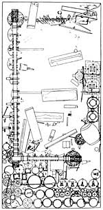
In 1977, archaeology excavations in Leigudun, Suixian in Hubei province found a remarkably rich and undisturbed tomb. Inscriptions on some of the bronzes indicated that it belonged to Yi, marquis of Zeng (Zenghou Yi in Chinese) and dated to about 433 B.C. The existence of the state of Zeng was unknown until 1977, and it remains somewhat enigmatic. Some scholars feel it is simply an alternate name for the state of Sui, which was one of the chief rivals of the powerful Chu, although it may also have been a lesser neighboring state.
Originally sunk to a depth of 13 meters, the tomb was packed with charcoal, and the shaft filled with clay, stone slabs, and earth. The durability of these materials, and the fact that the tomb became waterlogged, left it in a remarkable state of preservation, enabling archaeologists to determine precisely how goods were distributed in the four chambers. These chambers mirrored the arrangement of the marquis' palace during his life. The eastern chamber, representing his private quarters, contained his own lacquered double coffin, the coffins of eight young women (ages thirteen to twenty-four) who were probably concubines or musicians to entertain Yi in the afterlife, and a dog buried in its own coffin.
The chamber also contained weapons, a chariot, and many personal items, including furniture, a zither, silk, and vessels -- though not bronze vessels. The central chamber (left) seems to have corresponded to the ceremonial hall of Yi's palace. Inside, were a large set of bronze bells (similar to the Chime of twenty-six bells) and other instruments, as well as bronze ritual vessels. The northern chamber served as an armory and storeroom, the western chamber, where thirteen more young women were buried, as servants' quarters.
The marquis' tomb illustrates a transition from tomb traditions that replicated the ritual environment of ancestral temples to a new conception of the tomb as a recreation of the deceased's earthly existence.

Wednesday, July 28, 2010
The Mummification Process
The ancient Egyptians developed a sophisticated method to preserve a dead body for the afterlife: mummification. First, the internal organs were removed and all moisture from the body was eliminated. Next, the body was wrapped with long strips of linen, and then covered with a large linen cloth. Follow the steps of the mummification process in this short animation about the Getty Museum's Romano-Egyptian mummy Herakleides.
Sunday, July 25, 2010
Excavation on battles-fields 2008
Archaeologists have discovered an ancient roman battlefield from the third century near Göttingen that will rewrite history, Lower Saxony's department for preservation of historical monuments said on Thursday.
“The find can be dated to the third century and will definitely change the historical perception of that time,” Dr. Henning Haßmann told The Local.
The amazing discovery allows an insight in what must have been a dramatic battle between Romans and Germanic tribes. “The find indicates a massive Roman military presence,” Habmann said.
So far historians believed that the battle of the Teutoburg Forest, which took place in 9 AD, resulted in the Roman’s Empire withdrawal from Germania without any further attempt to conquer the land beyond the Rhine River again. But the unearthing of the battleground near the village of Kalefeld proves that Rome didn't give up its expansionary ambitions until much later than previously assumed.
“It is pretty normal to find evidence of Roman culture all over even up in Scotland, but a find like this in northern Germany is really amazing,” Haßmann said. “And it's spectacularly well preserved.”
The archaeology digs has already brought some 600 artefacts to light during the last three months, most of them ancient weapons.
The exact location has been kept a secret so far, to keep private collectors at bay, Haßmann said. But it will be revealed on Monday by Lower Saxony's minister for science and culture, Lutz Stratmann, as well as the archaeologists that were involved in the excavation.