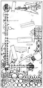
Excavations in Daghestan
David Stronach
Daghestan, "The Land of Mountains," lies in Southern Russia at a point where the high ranges of the Caucasus most closely approach the western shore of the Caspian Sea. The mountain ridges never completely sever the long narrow Caspian littoral plain, however, and it is this thin ribbon of flat land that has formed a vital corridor from time immemorial between the Eurasian steppes to the north and the inviting lands of the Near East to the South. It has always been an invasion route, usually but not always for nomadic groups pressing southwards from the steppes. But it has also served as a major artery for the transmission - in each direction - of ideas and technology; and it could have been via this particular route the domesticated horse eventually reached Upper Mesopotamia in the late third millennium B.C.
The present account is intended to provide a brief description of two seasons of excavation which took place in Daghestan in 1994 and 1995 at the Chalcolithic and Bronze Age site of Velikent - a settlement that sits astride the coast road at a point 25km to the north of the ancient fortified city of Derbent. Some note will also be taken of the still well preserved condition of the Sasanian walls of Derbent and the little-studied Long Wall of Khosrow I (531-579 A.D.), which stretches from Derbent for a distance of nearly 50km.
The surviving remains of the early settlement at Velikent (local building activities regularly nibble at the edges of the site) occupy the tops of five natural hillocks (Mounds I-V) that stand up to 9 meters in height. The mounds represent the remains of terraces left by the third transgression of the Caspian Sea and the early inhabitants can be seen to have situated their houses and their cemeteries on these clay-like "islands" that overlooked the surrounding, rich agricultural land.
The presence of archaeological materials at Velikent was first noted by the Russian archaeologist, A. Rusov, in 1882. The first controlled soundings took place in the mid-fifties and then, in the late 1970's and the early 1980's, more prolonged archaeology excavations were undertaken on behalf of the Daghestan Academy of Sciences. This latter work revealed one area with well preserved architecture on Mound I and elsewhere, on Mound III, several collective tombs were located and archaeology excavated.
The 1994 and 1995 seasons at Velikent
The most recent investigations have been conducted by a joint American-Daghestani team, led by Magomed Gadzhiev, Philip Kohl, Rabadan Magomedov, and myself. The American component of the team has included students from Wellesley College and graduate students from both the University of Arizona and U.C. Berkeley. Support for the Project has come from various sources including an extension of a grant from the National Endowment for the Humanities, the National Geographic Society, and the Irving and Gladys Stahl Foundation of the University of California at Berkeley.
In so far as our own investigations were partly informed by earlier work at the site, we decided to return to the area of the first excavations that had previously been conducted near the summit of Mound I. In this latter area we were able to re-examine the still relatively well preserved remains of three adjacent rooms within an elongated, heavily burnt building that can be dated, on the basis of pottery parallels from Transcaucasia, to the second half of the third millennium. It also transpired that the methods that had been used to construct this building were somewhat unexpected; and, with this in mind, we took steps, in 1995, to excavate part of a fourth room, to the north of the previous limit of archaeology excavations.
Room 4 proved to have been subject to especially intense burning. The wall plaster was discolored by fire and the interior of the room was found to contain huge fused masses of fallen plaster and other debris. Some of the pottery was vitrified and twisted into grotesque shapes by the effects of fire. Apart from the shattered remains of numerous vessels of local Kura-Araxes ware, the floor of Room 4 yielded a variety of small disc-shaped beads made from carnelian, paste, and shell (from the adjacent beaches of the Caspian). A copper object may very well represent an ingot; and, as such, it would constitute the first example of Early Bronze Age date to have been found in Daghestan. Also if interest was a single skull which was located not far above floor level - apparently unassociated with any other skeletal material (at least in the excavated portion of Room 4). According to preliminary studies of the skull now being conducted at U.C. Berkeley by Garry Richards and Michelle Bonogofsky this was the skull of a woman of about thirty-five years of age who had been suffering from a brain tumor. But whether or not this was the actual cause of death is not known since the top of the skull also shows the clear impress of a heavy, conceivably fatal blow.
As far as the original construction of the Burned Building is concerned, it's builders apparently began by digging a long trench into the natural clay surface of the mound. Wherever the natural clay deposit stood undisturbed by earlier, and deeper, Early Bronze Age circular pit dwellings, this extended trench permitted the builders to count on the presence of hard clay side walls and a solid clay floor. In such areas they simply lined the opposing long sides of the excavated area with stone courses set in mortar. The large river boulders in these side walls vary from 20 to over 60cm in length, with the largest stones necessarily resting near the base of the wall. And while the stones were usually laid in successive courses of stretchers, they could also be laid in alternative courses of headers and stretchers (or even inserted as upright "fillers"). Above a height of one meter the long walls were probably carried up in mudbrick since the Burned Building's cross-walls were constructed of mudbrick alone. In addition, the weight of the roof was at least partly carried by vertical oak posts, the bases of which were found in situ in a carbonized condition.
On Mound II two separate trenches, one of which was supervised by Ms. Shoki Goodarzi-Tabrizi of U.C. Berkeley, have been used to test what appears to have been a relatively long occupation sequence stretching from the early Bronze Age back into the Late Chalcolithic. It should be added that carbon samples submitted to the AMS Facility of the University of Arizona from the deeper levels of Mound II have so far yielded four calibrated C14 dates that are tightly clustered between 3300 and 2950 B.C. Seed remains from both Mounds I and II were also collected with the aid of a floatation system and the seeds in question are currently awaiting analysis in the United States. Elsewhere, on Mound III, a previously plundered mid-third millennium collective tomb yielded two finds of special note. The first is a spiral gold ringlet with flattened finials (the first object of gold so far known to have been found in any of the Velikent tombs) and the second is a copper or bronze ax that is similar in form to axes that are otherwise known from Late Maikop burials in the far northwest region of the Caucasus.
The Sasanian Walls of Derbent
Time was also taken, in association with Dr. A. Kudriavtzeff and Dr. M. Gadjiev to examine the impressive sixth century stone fortifications in and near Derbent that were erected by the Sasanian ruler, Khosrow I, in order to protect Iran from the depredations of nomadic invaders who were then pressing down the narrow coastal corridor from the north. Remarkably enough, the tall walls of the main citadel at Derbent, the walls and towers of the lower city walls that run down to the seashore, and the walls of the hill-top defensive wall that runs inland for a distance of 46km are each characterized by the same distinctive from of stone masonry. A review of contemporary monuments in Iran indicates that just this kind of finely worked header-and-stretcher masonry was also employed in the construction of the main gateways at the celebrated Sasanian site of Takht-i Sulaiman.
Since the formidable Long Wall of Khosrow I, and the much earlier remains are beginning to be revealed in some detail at Velikent, each stand in definite need of further investigation, it is much to be hoped that local conditions in the war torn North Caucasus will indeed permit an early resumption of the promising collaborative work that has taken place so far.
Friday, July 30, 2010
Excavations in Daghestan
Huge Roman coins find for hobbyist
One of the largest ever finds of Roman coins in Britain has been made by a man using a metal detector.
The hoard of more than 52,000 coins dating from the 3rd Century AD was found buried in a field near Frome in Somerset.
The coins were found in a huge jar just over a foot (30cm) below the surface by Dave Crisp, from Devizes in Wiltshire.
"I have made many finds over the years, but this is my first major coin hoard," he said.
After his metal detector gave a "funny signal", Mr Crisp says he dug down 14in before he found what had caused it.
"I put my hand in, pulled out a bit of clay and there was a little Radial, a little bronze Roman coin. Very, very small, about the size of my fingernail."
Mr Crisp reported the find to the authorities, allowing archaeologists to excavate the site.
Offering to gods
Since the discovery in late April, experts from the Portable Antiquities Scheme at the British Museum have been working through the find.
Advertisement
Dave Crisp explains how he discovered the coin hoard
The coins were all contained in a single clay pot. Although it only measured 18in (45cm) across, the coins were packed inside and would have weighed an estimated 160kg (350lb).
"I don't believe myself that this is a hoard of coins intended for recovery," says Sam Moorhead from the Portable Antiquities Scheme.
"I think what you could see is a community of people who are actually making offerings and they are each pouring in their own contribution to a communal ritual votive offering to the gods."
It is estimated the coins were worth about four years' pay for a legionary soldier.
"Because Mr Crisp resisted the temptation to dig up the coins, it has allowed archaeologists from Somerset County Council to carefully excavate the pot and its contents," said Anna Booth, local finds liaison officer.
Somerset County Council Heritage Service now hope the coroner will declare the find as treasure. That would allow the Museum of Somerset to acquire the coins at market value with the reward shared by Mr Crisp and the land owner.
The story of the archaeology excavation will be told in a new BBC Two archaeology series, Digging for Britain, presented by Dr Alice Roberts and made by 360production, to be broadcast in August.
Arcadia Mill Archaeology Site and Museum Reopened!
After extensive renovations following the destructive effects of Hurrican Ivan, the Arcadia Mill Archaeology Site and Museum just to the north of Pensacola has finally reopened. Arcadia is one of the oldest industrial sites in the Southeast. Built in the late Spanish colonial period (1817) and burned in 1855, this water-powered industrial complex had a sawmill, grist mill and slave-labor textile factory before the Civil War. Arcadia has been developed for the public and is handicapped-accessible. Arcadia House has a wide variety of artifacts on display associated with saw milling and cotton cloth production. The site is deeply wooded with trails which include a swinging bridge over Pond Creek and a long, beautiful boardwalk over the levees which leads visitors to the unique sandstone masonry foundations and old textile plant floors.
The site is open from Tuesday through Saturday, 10 a.m. to 4 p.m. For more information, contact site director Monica Beck at (850) 626-3084 or mbeck@uwf.edu.

UWF Archaeologists Discover Second Oldest Shipwreck in the U.S.
It was the last week of Archaeology field school in the summer of 2006 when two University of West Florida students found a few stones lying on the floor of Pensacola Bay and thought there may be something more. That’s all it took for John Bratten and Gregory Cook, both maritime archaeology professors at UWF, to look further and find that they had a lot more on their hands than a few stones. UWF publicly announced that after several months of evaluation, the shipwreck in Pensacola Bay formerly known as “Target 17” is the remains of one of the colonization ships of the Tristan de Luna fleet that sank in Pensacola Bay during a hurricane in 1559.

Division of Anthropology and Archaeology


“CSI: UWF” - Field School Teaches Students How to Research Bones.
Transforming the campus into a mock scene straight out of the hit television show “CSI: Crime Scene Investigation,” the University of West Florida Department of Anthropology will offer a unique, hands-on course this summer. The Forensic Anthropology Field School, a course that teaches students how to successfully and efficiently find and handle skeletal remains, will be held May 11 through June 12.
“Our field school focuses on field techniques for discovery, documentation and recovery of human skeletal remains,” said Joanne Curtin, associate professor of Anthropology. “Students learn proper search, mapping and archaeology excavation techniques. They also learn field photography, reporting and presentation skills.”
As part of the field school, two study skeletons have been buried on the UWF campus. The students were provided with a mock scenario in which someone killed and buried two people in the woods at UWF. The suspect confessed to the murders and burying the bodies, but cannot recall exactly where the bodies were buried. The forensic anthropology students are tasked with locating, mapping, photographing, archaeological excavating and reporting on the skeletal remains.
“The course gives students hands-on experience practicing a variety of skills essential to forensic anthropology,” said Curtin. “UWF is one of a few institutions in the United States to offer a field school of this nature.”
In addition to the on-campus exercise, students in the course will also have the opportunity to conduct research at St. Michael’s Cemetery in downtown Pensacola. The students will investigate and conduct test archaeology excavations of a suspected mass grave in the cemetery. UWF archaeologists have identified a few subsurface anomalies at the cemetery that they believe may be connected to the yellow fever plague that swept through Pensacola during the 19th century. Although no one has confirmed with certainty on what may have happened, Margo Stringfield, researcher with the UWF Archeological Institute, has a theory.
“Margo (Stringfield) suspects that when the epidemic swept through Pensacola, the residents may have made a mass grave and buried all of the victims in one place.” said Curtin. “The students will have the opportunity to work in the cemetery and assist in finding out if the anomalies are indeed part of a mass grave.”
The UWF Anthropology Field School is open to all majors, but is especially recommended for anthropology majors specializing in biological anthropology. Prerequisites for the course include “Biological Anthropology,” “Principles of Archaeology” and “Human Osteology” with a grade of “C” or better.
Thursday, July 29, 2010
Maritime Archaeology UOG Course Takes Students Down
Guam - Students enrolled in the University of Guam’s Maritime Archaeology course spent a good deal of their class time this summer underwater obtaining hands on experience in the practice of maritime archaeology and underwater cultural heritage.
Students learned field techniques in recording and documenting a site, including an underwater archaeology survey and an assessment of a site, and the theoretical and practical ways in researching and managing these sites and their histories. The course also included assessment of the state of conservation of the site in addition to basic artifact conservation.
The course was taught by maritime archaeologist Dr. Bill Jeffery and assistants along with University of Guam instructors Douglas Farrer and Todd Ames.
The course was sponsored by the UOG College of Liberal Arts and Social Sciences, the Micronesia Area Research Center, and the Guam Preservation Trust, among others, and incorporated the Nautical Archaeology Society Training Program into the coursework. This is the second consecutive summer that the course has been offered and the partners hope to build capacity in the area of underwater cultural heritage on Guam and in the region.

Staffordshire Hoard and Lindow Man Bog Body Mystery win British Archaeological Awards
The Manchester Museum’s investigation into a preserved Iron Age body found in a Cheshire bog 26 years ago and the discovery of the epochal Staffordshire Hoard last year have been announced among six winners in this year’s British Archaeological Awards.
Lindow Man: A Bog Body Mystery Exhibition unravelled the story of the gristly corpse, discovered on Lindow Moss in 1984, in a year-long display of revelations from forensic archaeologists, archaeology digs experts, druid priests and humble curators.
“There are few moments in life when you can look into the face of someone who is 2,000 years old and ask questions about them,” Bryan Sitch, the Head of Humanities at Manchester University, said at the time.
“This exhibition offers a unique opportunity to do just that.”
The show drew widespread acclaim between April 2008 and April 2009, including recognition in the 2009 Design Week awards and an accompanying photographic exhibition by Stephen Vaughan documenting the mythical status and physical changes bestowed upon the bog during the four-year archaeology excavation process.
The Staffordshire Hoard became the most lucrative stash of Anglo-Saxon gold ever found in the UK when it was unearthed by amateur metal detector Terry Herbert in fields near Lichfield – at the heart of the ancient Kingdom of Mercia – in September 2009.
Later saved for the nation at a cost of £3.285 million following an impassioned campaign by museums and councils in Birmingham and the Potteries and The Art Fund, the Hoard drew record crowds to Birmingham Museum and Art Gallery and the Potteries Museum between September 2009 and April 2010.
Other winners include York University’s Tarbat Discovery Programme, which won Best Archaeological Project for a 16 year campaign of investigation of the large 6th-8th century Pictish Monastic settlement at Portmahomack, and the Thames Discovery Programme in the Best Representation of Archaeology in the Media category.
Fin Cop Hillfort, a pit archaeology excavation in the Derbyshire region of the Peak District, was named Best Community Archaeology Project.
“These awards have gone to the very best of British archaeology from the last two years,” said Awards Chairman Dr Mike Heyworth, congratulating the nominees in a ceremony at the British Museum.
“We congratulate all the winners and are hugely encouraged by the public interest in archaeology and the enthusiasm shown across the UK for our archaeological heritage, as we have seen in particular with The Staffordshire Hoard.”


Archaeology in Southwark
Southwark has an immensely rich and important archaeological heritage dating from 10,000 years ago to the industrial remains of the last century.
The Romans set up their provincial capital of Britain at a settlement near London Bridge and Borough High Street. This area was also the location of the medieval settlement of Long Southwark, famed for its fairs and inns.
The areas of archaeology excavation importance stretch beyond this to include Bankside where important Elizabethan and Stuart playhouses such as the Globe and the Rose were located. Historic villages further south also contain important archaeological information.
Southwark Council has policies to protect the borough's archaeology and a dedicated archaeology officer ensures that these are adhered to.


Archaeology Excavations and Heritage Sites
We aim to promote the understanding, appreciation and sustainable conservation of Buckinghamshire's archaeological Excavation.
Planning and land management advice
We develop policies for the management and conservation of archaeology excavation remains and historic landscapes and provide related advice to local planning authorities and other organisations. We do not undertake archaeological fieldwork - this is done by commercial archaeological contract organisations.
Historic Environment Record and Unlocking Buckinghamshire's Past
We are responsible for the maintenance and development of Buckinghamshire's Historic Environment Record. This is a public access record of the whole of the historic environment of the county from the earliest humans to the end of the Cold War. A user-friendly version with loads of additional resources including illustrations, education packs, a timeline, interactive games and visitor guides is available online at Unlocking Buckinghamshire's Past. The online database is also available on English Heritage's Heritage Gateway.
Projects
We have undertaken a number of externally-funded characterisation projects to develop our understanding of Buckinghamshire's historic landscapes and townscapes. Work includes Historic Landscape Characterisation of Buckinghamshire and Milton Keynes for English Heritage, a number of characterisation projects in the Chilterns AONB area for the Chilterns Conservation Board, Historic Landscape Characterisation of the Colne Valley Park for Groundwork Thames Valley, and we are currently working on a Historic Towns project for English Heritage. We are also involved in developing regional archaeological research frameworks for the Solent-Thames region.
New book and exhibition
Buckinghamshire Archaeological Society has published the first new book on the early history of the county to appear in many years. An Illustrated History of Early Buckinghamshire is edited by Michael Farley and includes contributions by past and present County Archaeologists. Covering the period from the Ice Ages to the Tudors, the book is aimed at a popular audience and is lavishly illustrated. Copies are available through the society and in the museum shop and cost £15.99.
Use the menu on the left to find more information on all these projects and other work we are involved with.
Source from Great Site : http://www.buckscc.gov.uk


Part Three: Chu and Other Cultures
In 1977, archaeology excavations in Leigudun, Suixian in Hubei province found a remarkably rich and undisturbed tomb. Inscriptions on some of the bronzes indicated that it belonged to Yi, marquis of Zeng (Zenghou Yi in Chinese) and dated to about 433 B.C. The existence of the state of Zeng was unknown until 1977, and it remains somewhat enigmatic. Some scholars feel it is simply an alternate name for the state of Sui, which was one of the chief rivals of the powerful Chu, although it may also have been a lesser neighboring state.
Originally sunk to a depth of 13 meters, the tomb was packed with charcoal, and the shaft filled with clay, stone slabs, and earth. The durability of these materials, and the fact that the tomb became waterlogged, left it in a remarkable state of preservation, enabling archaeologists to determine precisely how goods were distributed in the four chambers. These chambers mirrored the arrangement of the marquis' palace during his life. The eastern chamber, representing his private quarters, contained his own lacquered double coffin, the coffins of eight young women (ages thirteen to twenty-four) who were probably concubines or musicians to entertain Yi in the afterlife, and a dog buried in its own coffin.
The chamber also contained weapons, a chariot, and many personal items, including furniture, a zither, silk, and vessels -- though not bronze vessels. The central chamber (left) seems to have corresponded to the ceremonial hall of Yi's palace. Inside, were a large set of bronze bells (similar to the Chime of twenty-six bells) and other instruments, as well as bronze ritual vessels. The northern chamber served as an armory and storeroom, the western chamber, where thirteen more young women were buried, as servants' quarters.
The marquis' tomb illustrates a transition from tomb traditions that replicated the ritual environment of ancestral temples to a new conception of the tomb as a recreation of the deceased's earthly existence.

Wednesday, July 28, 2010
The Mummification Process
The ancient Egyptians developed a sophisticated method to preserve a dead body for the afterlife: mummification. First, the internal organs were removed and all moisture from the body was eliminated. Next, the body was wrapped with long strips of linen, and then covered with a large linen cloth. Follow the steps of the mummification process in this short animation about the Getty Museum's Romano-Egyptian mummy Herakleides.
Excavations restarting at İkiztepe in northern Turkey
İkiztepe ancient site, which was discovered by archaeologists in 1940 in the Black Sea city of Samsun's Bafra district, is being excavated for 36 years and nearly 11,550 artifacts have been unearthed so far. This year's archaeology excavations has restarted in the region and will continue until Sept 10.
Excavations at İkiztepe, which have continued in the Black Sea province of Samsun’s Bafra district since 1974, are being carried out in the area again this year.
İkiztepe was discovered in 1940 by archaeologists who carried out excavations in the Dündartepe region around Samsun.
Many artifacts from the early Bronze Age (3000-2000) and the Hittite period (1900-1800 BC) have been unearthed so far during the excavations led by the Istanbul University Archaeology Department’s Professor Önder Bilgi.
“This year’s excavations, which have continued in İkiztepe for 36 years, will end on Sept. 10,” said Bilgi, adding that they finished works in one area last year and searched for layers of the early Bronze Age period.
“The number of findings that have been unearthed in İkiztepe reached nearly 11,550. Last year’s excavations were carried out at Hill One and have ended. This year’s excavations continue on a slope that we call İkiztepe. A team of 34 people, including five students and three expert anthropologists, is working there. Last year significant artworks were found, revealing the cultural development in the region. We also had a chance to profile the layers of the early Bronze Age. Two furnaces and two graves have been unearthed so far,” Bilgi said, adding that the archaeology excavations shed light on the cultural history of the central Black Sea.
Settlements until 1700 BC
During the excavations, which had been carried out at the ancient site, traces of Caolithic period (between 5000-4000 BC) were found, which revealed that the settlement existed there until 1700 B.C.
A tumulus from the Hellenistic period (330-39 BC) was found as well as a number of artworks and remnants from the early Bronze Age. Weapons, furnaces, symbols, jewelry and stone tablets found during the excavations show that the people of İkiztepe played an important role in the development of the Anatolian art of mining. It is known that they used a mixture of copper and arsenic in metal objects, and it is estimated that they obtained copper from the Merzifon region and arsenic from Gümüşhacıköy in present-day Amasya.
The most interesting findings unearthed during the excavations are skulls, which underwent surgical operation. In the graveyard on the highest hill in the ancient site, dating back to 2300-2100 BC, eight out of the 690 skeletons had skulls with traces of surgical operation. These skulls have archaeological importance since they are the only ones unearthed in Anatolia. They also show that people who lived there did not have the characteristics of Mediterranean people but of southern Russians and Bulgarians.
Some of the findings from the İkiztepe excavations are being displayed at the Samsun Archaeological and Ethnography Museum.
Source from Great site : http://www.hurriyetdailynews.com

Archaeological dig concludes
A six-week-long archaeological excavation recently concluded in downtown Hastings near the Highway 61 bridge.
The site was once home to the St. John’s hotel and a neighboring saloon. Both were destroyed by one of the largest fires in Hastings history, the Christmas fire of 1899.
Crews from Two Pines Resource Group found evidence of the fire, uncovering brick rubble and burned wood and ash. The hotel was rebuilt and stood on the site until 1983. Many artifacts from the site’s time as a hotel were uncovered, including broken fragments of bottles, dishes and glassware. Crews also found old coffee beans, fish bones, animal bones and egg shell fragments.
Two Pines also found a number of interesting personal artifacts, ranging from a small China cat, marbles, tobacco pipes, combs and buttons at the site.
“The overall integrity of the site was just so good,” said Michelle Terrell of Two Pines. “A lot of times, people think that, especially in a rural area like Hastings, how can things survive as well, and as long, as they do?”
Crews were at the site from May 17 to June 30. They are now busy cleaning and identifying the thousands of artifacts collected.
A complete report detailing the findings will be finished next year. A local display of some of the artifacts from the project is planned.
“There was just so much interest from the community (while crews were at the site),” Terrell said. “We’d like to do something local so everyone can see the artifacts. I think you’ll be able to see some interesting things.”
It will take a few months for the team to complete its work, so any such exhibit is a ways off yet.
“We’re still working our way through the analysis,” Terrell said.
One member of the Two Pines team is combing through the various bones that were found so as to determine what animal they came from. That will help archaeologists determine what sorts of resources were being used to feed guests at the hotel and patrons of the saloon. Thus far, the obvious bones were found, including those from cows, pigs and chickens. There were bones from fish, deer and ducks.
Two Pines conducted a preliminary archaeology dig in 2008 to see what lay below the surface. They found the foundation of the hotel building and a few artifacts. That led federal, state and local agencies to agree the remains were historically significant and should undergo further archaeological investigation prior to construction of the new bridge.
Source: http://www.dglobe.com

Archaeologists Find Ancient Hammurabi-Like Law Code in Israel Clay Tablet
Archaeologists have uncovered for the first time in Israel fragments of a law code that resemble portions of the famous Code of Hammurabi.
The code was found on two fragments of a clay tablet, and is between 3,700 and 3,800 years old, the Hebrew University of Jerusalem said today in an e-mailed statement.
The fragments “refer to issues of personal injury law relating to slaves and masters, bringing to mind similar laws in the famous Babylonian Hammurabi Code of the 18th century B.C. that were found in what is now Iran over 100 years ago,” the statement said. “The laws also reflect, to a certain extent, biblical laws of the type ‘a tooth for a tooth’.”
The discovery opens an interesting avenue for investigation of a connection between Biblical law and the Code of Hammurabi, according to Wayne Horowitz of the Hebrew University Institute of Archaeology, who is preparing the law code fragments for publication. The style of the text is similar to that of the Hammurabi Code, he said.
The tablet, written in Akkadian cuneiform script, was discovered in Hazor, in the north of Israel. Words that have been deciphered include “master,” “slave” and a word referring to bodily parts, apparently the word for “tooth.”
The two fragments are the 18th and 19th cuneiform finds from the Hazor excavations, which now form the largest body of documents of cuneiform texts found in Israel. Previous documents found dealt with subjects including the dispatch of people or goods, a legal dispute, and a text of multiplication tables.
The Hazor archaeology excavations are under the direction of Amnon Ben-Tor and Sharon Zuckerman of the Hebrew University. Previous excavations were directed at the site by Yigael Yadin in the 1950s and 1960s.
To contact the reporter on this story: Alisa Odenheimer in Jerusalem at aodenheimer@bloomberg.net
Source : http://www.bloomberg.com

Archaeology: Excavations on St. Ivan island reveal potential relics from John the Baptist
Archaeology Excavations on Saint Ivan island, the largest of five Bulgarian islands in the Black Sea, have unearthed an exquisite marble reliquary incorporated into the church’s altar, the historian Bozhidar Dimitrov, director of the National History Museum and minister without portfolio in charge of Bulgarians abroad, told Focus news agency on July 28 2010.
He suggested that the reliquary might hold the relics of John the Baptist.
Once the island was converted to Christianity, a monastical complex was built between the 5th-6th century on top of the ruins of the old Roman temple, including the Basilica of the Mother of God. Around the 7th-9th century, the basilica was abandoned only to be reconstructed in the 10th century.
The Monastery of John the Forerunner and the Baptist grew into an important centre of Christianity in the region. Archaeological research was carried out after 1985 for a a period of two years, which revealed a royal residence, a library, part of the fortified wall with the gate and several monastic cells.
Kazimir Popkonstantinov, an archaeologist professor is overseeing the archaeology excavations on the island. Dimitrov said that the reliquary will be opened for the media in a few days after the "necessary religious ceremonies are carried out".
St. Ivan is the largest Bulgarian island in the Black Sea, with an area of 0.66 square kilometres just off the Bulgarian Black Sea coast near Sozopol, a town rich in history and a popular tourist destination, and is separated by a strait several hundred metres long from the small neighbouring St. Peter Island. It is 920m from the Stolets peninsula, the location of Sozopol's Old Town.

Archaeologists Discover 2,400-Year-Old Weapons and Tools in Valencia
The hilt of an eagle-shaped sword dated from 4th Century B.C. and made of iron is pointed at by one one of the archaeologists working at an archeology excavation in the site of La Bastida de les Alcusses in Moixent, Valencia, during its presentation at Archeological Museum of Valencia, Spain 28 July 2010. Five sets of iron weapons belonging to Iberian warriors, and dated from 4th B.C. were found at the site of Bastida de Les Alcusses two weeks ago and presented, among others, by director of Prehistory Museum of Valencia, Helena Bonet (not seen) on 28 July 2010. EPA/MANUEL BRUQUE.
VALENCIA.- The finding of a set of useful weapons for warriors from 2400 years ago in La Bastida de les Alcusses located in Moixent (Valencia) has confirmed this excavation as "the peninsular town of reference to study the Iberian period."
This has been assured by the delegate of the department of Culture of the Provincial Council of Valencia, Salvador Enguix, the director of the Museum of Prehistory of Valencia and co-director of the excavation campaign, Helena Bonet, and archaeologist and co-director of the excavation at La Bastide Alcusses, Jaime Vives-Ferrandiz, have presented at a press conference the details of the findings announced yesterday by the county.
Excavations have recovered over 60 iron objects in a small area of the western entrance to the village of La Bastida, including weapons, rods and nails belonging to the jamb of a door, the experts explained.
Archaeological excavations in the Iberian settlement of La Bastida de les Alcusses of Moixent have been indertaken this year in the West Gate. This entry to the town had already been excavated in 1998 but the evidence of the existence of an older entry at this point has led to the excavation this year.
In this set, stand out outfits - set of weapons and tools - for warriors located in the village. There are, Helena Bonet said, five sets of weapons, belonging to as many Iberian warriors from 2,400 years ago, which are the "most spectacular" find and enable to document "a unique ritual in Iberian Archaeology consisting of the intentional deposition of five complete sets of iron weapons, food offerings and ceramic vases, all burned together with wood and iron structures of the door and sealed under a layer of earth. "

Tuesday, July 27, 2010
Smuggs - Smugglers' Notch Archaeology Dig
Join archaeologist Corbett Torrance and discover the past on Vermont's Lamoille River. Abenaki artifacts from 1,000 years ago have been discovered in the river valley below Smugglers' Notch, and we invite you to join the dig or take a tour of the site. Special thanks to Underhill resident Nathan Steinbauer for this submission.
The Castlemilk Archeological Dig
On the site of Castlemilk House The Dig was commissioned by The Castlemilk History Group and carried out by Glasgow University Archaeological Research Division.
(GUARD)Under the direction of Robert Will and Alan Leslie.
Funded by Glasgow District Council. Oct 1991
Glasgow Archaeological Dig 2007
Archaeologists from around the world came to Glasgow to dig at the site of what will be the M74 road.
Archaeological dig at Marlboro College
Friday, Aug. 29, students from Marlboro College teamed up with archaeologists from Hartgen archaeological Associates Inc., to conduct a dig at the Mumford House at Marlboro College to find artifacts and data pertaining to an old mill owned by the Mather family, one of several mills known as "Mather's Mill," which made up one of the main centers of industry in Marlboro in the 1800s. The dig is a segment of Marlboro College's "Bridges Orientation," program for incoming students.
Urban archaeology digs life in colonial Boston
Remember," says archaeological historian Nancy Seasholes as she stands in front of Boston's Faneuil Hall, pointing toward City Hall. "Think land on this side." Then she turns around and gestures in the opposite direction, to Quincy Market, "Think docks and water on this side."
Boston city archaeologist Ellen Berkland (GRS'89) and Mary Beaudry, a CAS associate archaeology professor (both at right), prepare the class for a tour of the Paul Revere House in the North End. The house was built in 1680; Revere owned it from 1770 to 1800. Photo by Kalman Zabarsky
Boston city archaeologist Ellen Berkland (GRS'89) and Mary Beaudry, a CAS associate archaeology professor (both at right), prepare the class for a tour of the Paul Revere House in the North End. The house was built in 1680; Revere owned it from 1770 to 1800. Photo by Kalman Zabarsky
Quincy Market under water? As students in the CAS summer course Archaeology of Colonial Boston follow guest lecturer Seasholes along the ancient shoreline of the city - now covered with downtown's streets and buildings - they learn how little the area resembles the original terrain.
"When Boston was founded in 1630, it was a small peninsula with 470 acres of land," says Seasholes (GRS'94). "The downtown area was a virtual island connected by a narrow neck that is now Washington Street." The land area of central Boston has tripled over the past 372 years because of massive filling projects that created such neighborhoods as the Back Bay and much of East Boston.
"Think ocean to your left," says Seasholes as the class crosses State Street and heads down Kilby Street. There used to be a small harbor inlet at the intersection of Kilby and Water Streets, she tells students. Bostonians crossed over the water here by a drawbridge, hence the name of the street. The origin of Oliver Street is the long-buried Oliver's dock, pieces of which Seasholes found years ago in a dig on State Street. To be sure, remnants of colonial Boston are scattered around the city for those who look hard enough: the class has also visited such buildings as the King's Chapel (1754) and the Old South Meeting House (1729). Still, with car horns blaring and hot asphalt underfoot, it's nearly impossible to imagine wharves and water a block away from what is now Post Office Square.
Indeed, in the age of cell phones, computers, and the Internet, it's hard to comprehend what daily life in Boston was like during colonial times, even in a city known for its history - with some of its 17th and 18th century buildings still standing. But that's the goal of the course taught by Mary Beaudry: unearthing the city's past and bringing it to life to BU undergraduates. And the associate archaeology professor is uniquely qualified to expound upon Boston's buried history because she has dug up, literally, so much of it. She has been involved in some of the city's most important archaeology excavations, including digs at the Paul Revere House in the North End, the Bostonian Hotel, and the Central Artery/Tunnel Project.
The Paul Revere House
Only one of Beaudry's six students is an archaeology major, a visiting student from McGill University. The other five soon discover that the discipline is not about finding treasure or uncovering ancient curses. Far from an Indiana Jones or Lara Croft-style adventure, an archaeological excavation is often fairly mundane. After all, it is the study of people's everyday lives. A dig can mean spending many long, boring days in a hole and uncovering nothing.
But the field can also be exciting, and Beaudry recalls jumping at the chance to dig six pits outside the Paul Revere House in 1983 with BU colleague Ricardo Elia, an associate professor of archaeology. "I remember say-
ing, 'This place is throbbing with archaeological potential,' " says Beaudry. "It was built in 1680. It's the oldest house in Boston, and we found a privy in the courtyard." Only an archaeologist could get so revved up about a backyard outhouse pit/garbage dump. Rooting through 300-year-old refuse might not be everyone's idea of a good time, but to Beaudry trash is treasure. Digging in a colonial privy is a surefire way to come up with artifacts, and the BU excavation team found 12,587 of them, including ceramics, metal, glass, wood, and food remains - which allow experts to reconstruct colonial diets.
Scott Miller (CAS'02) and Beaudry look for artifacts on a sifting screen on Rainsford Island in Boston Harbor. Photo by Vernon Doucette
Scott Miller (CAS'02) and Beaudry look for artifacts on a sifting screen on Rainsford Island in Boston Harbor. Photo by Vernon Doucette
After a tour of the house, Beaudry brings her students to a garden where she dug a pit 19 years ago. She notices a lump in the dirt. She dusts off the object, looks at it carefully, and smiles. "Wow, isn't that something?" she says. "It's a piece of 18th-century wine glass, just like some of the artifacts we found in '83. It must have come right to the top when the gardener was turning over the soil." The students are amazed to see a piece of colonial Boston dug up right before their eyes, but this type of find is common in highly populated areas, explains guest lecturer Ellen Berkland (GRS'89).
"When you do urban archaeology, artifacts can be found 10 centimeters below the surface," she says. As Boston's city archaeologist, however, she also knows the drawbacks of such research in a city setting: archaeological remains are under constant threat of destruction because of the pace of development. So when potential archaeological sites downtown were identified where construction workers were planning to dig the massive Central Artery project, Berkland went to work.
The Big Archaeology Dig
From 1992 to 1995, she and other archaeologists investigated 12 sites along the Big Dig's 7.5-mile corridor. Four of them were eligible for listing in the National Register of Historic Places: a former mill pond along Blackstone Street, Paddy's Alley, the Cross Street back lot site in the North End, and Spectacle Island, where Big Dig workers hauled excavated soil to create a park. In fact, stone tools and harpoons made of bone found in a shell heap on the island revealed that Native Americans had gathered there as early as a.d. 500.
The students follow Beaudry and Berkland several blocks over to take the wine glass piece to the Boston City Archaeology Laboratory on Cross Street, where excavated items are gradually and carefully being washed and catalogued by BU archaeology students and other volunteers. "We found tin-glazed cups and bowls made in Holland," says Berkland, who passes around several tobacco pipe stems and bowls. "We also have leather shoes and the remains of a mug bearing the seal of Queen Anne, which dates a portion of the Paddy's Alley site to the early 1700s."
The Big Dig artifacts offer snapshots of colonial lives and livelihoods. Archaeologists also found the remains of houses owned by men who shared the same profession during the middle 1700s, but had very different lifestyles. John Carnes, who lived near the Paddy's Alley site, and William Maycock, whose home was next to the Mill Pond site, were both metalworkers. Carnes worked primarily in tin, while Maycock smelted brass in stone crucibles. Carnes was a hardworking man, and he obviously had some money. He was proud of the fact that he put his son through Harvard selling pewter tableware. He was also apparently wealthy - and thirsty - enough to order English wine bottles with his full name embossed on the seals, several of which were uncovered and are on display at the State Archives/Commonwealth Museum at UMass-Boston, where some 200,000 Big Dig artifacts are stored. Maycock was also fairly wealthy, but may have been a teetotaler. The site of his house was devoid of any wine bottle glass, even though he lived on the lot with tenants. His will attests to the importance he placed on a sober and moral life: he stipulated that his two sons inherit no property until they changed their wild lifestyles. Since his entire estate later went to his son-in-law, can we infer that Maycock's sons failed to reform? Archaeology is full of assumptions.
"This is a great course," says Kent Randall (SMG'03). "I had a vague idea of colonial life because, of course, I read about it in history classes growing up. But when I see the artifacts firsthand, it makes the period much more real to me."
Rainsford Island
A field trip the students make on another day is to Rainsford Island, one of 38 Boston Harbor islands. "These are the ruins of a quarantine hospital, which was originally built in 1832," says Berkland as she stands atop a crumbling stone foundation. "There have been several buildings on this island - the first was built in 1737. There was also a poorhouse, a veterans' home, a home for female paupers, and a reformatory for delinquent boys. By 1935 the buildings became vacated, and they were all destroyed by fire in subsequent years."
Down a pathway, the students are in for a treat. Because the island is usually off limits to the public, not many people are privileged to view the "graffiti rock." After a short hike to a stone bluff on the east side of the island, students read carvings dating back to 1647. "JVC Smith appointed physician of this island 1826," one reads.
A colonial-era chamber pot at the Boston City Archaeology Laboratory on Cross Street in the North End. Photo by Kalman Zabarsky
A colonial-era chamber pot at the Boston City Archaeology Laboratory on Cross Street in the North End. Photo by Kalman Zabarsky
The hike continues to an excavation pit being dug by Stephan Claesson (GRS'92), who is helping Berkland determine the history of the island's use. He lets Scott Miller (CAS'02) try his hand at looking for artifacts by sifting some dirt through a screen. "I'm an economics major, but I'm also a history buff," says Miller. "What's good about this course is that we don't just sit inside a class and listen to lectures, which is what economics majors do a lot. It's fun to get out here and do something like this."
This is the second summer that Beaudry has taught the course. Like Berkland, who teaches an archaeology elective in the Boston Public Schools, she likes to expose as many people as she can to the science. "I'm able to enlist a lot of help from former students and colleagues, and I think the present students appreciate that expertise," she says. "Plus, I know that they enjoy the field trips, not only because they are able to get out of the classroom on a hot summer day, but also they get to visit sites and handle the artifacts that are discussed in the lectures. A glimpse into the everyday lives of long-forgotten colonists can tell you a lot about the era."
Berkland agrees, recalling a Irish halfpenny dated 1783 that was discovered at the Mill Pond site - a significant find because there were no halfpennies made in 1783. The coin must be counterfeit, which raises the possibility of a colonial plan to sabotage the British economy. Or it may simply reflect the industriousness of a few early counterfeiters. "It was an exciting find," says Berkland, "but I try to stress to students that archaeology is not about digging for coins or gold treasure - it's about the information you get from the artifacts."


The Mummies of Ancient Egypt - Seminar
The Centre for Archaeology & Ancient History & The Egyptology Society of Victoria
Present
An afternoon of Lectures by Distinguished Authorities on Egyptian Mummies
Professor Salima Ikram, The American University Cairo, and Dr Aidan Dodson, University of Bristol
Saturday 31 July 2010
Programme (1pm to 5:30pm)
* Human Mummies and Mummification (S. Ikram);
* Theban Tomb 320: Priestly Catacomb to Royal Cache (A. Dodson);
* afternoon tea/coffee break;
* Introducing Animal Mummies(S. Ikram);
* The Sacred Animals of Saqqara (A. Dodson).
Venue, Date and Cost:
* Lecture Theatre H125, Building H, Caulfield Campus, Monash University
* Saturday 31st July; 1.00–5.30pm
* Cost: students/pensioners $20; ESV members $35; general public $50
* Bookings essential: Please send payment by cheque (payable to Monash University) or credit card details (Visa/Mastercard), and return address to Sharon Webb,
* School of Philosophical, Historical & International Studies, Building 11, Monash University, Clayton, 3800; or telephone 9905 2164.
* Download flyer here [103kb]
Image of Tutankhamun
Past events
The Latest Research on Tutankhamun: help or hindrance?
Centre for Archaeology and Ancient History and The Egyptology Society of Victoria present an illustrated public lecture.
Download flyer [pdf 121kb]
* Date: Friday 26 March 2010
* Time: 8.00pm
* Venue: Monash University Clayton Campus
Building 72, Lecture Theatre E7
Archaeology Excavations at the Tomb of Fu Hao
In 1976, near Anyang, the last Shang capital, archaeologists uncovered a Shang tomb, the only one that has been found intact. Tomb 5 contained the burial of Fu Hao, referred to in the oracle bones as one of the consorts of Wu Ding, twenty-first king of the Shang. The tomb, though modest in size, contained more than fifteen hundred objects. In addition to Fu Hao's own lacquered coffin were the skeletal remains of sixteen humans and six dogs. Among the more than seven hundred jades were examples that date from the Liangzhu culture (see Jade cong), which must have been collected as antiquities. Many bronze vessels were found, some of which were probably used by Fu Hao during her life. Others, which bear her posthumous name (Si Mu Xin), were probably cast as burial goods. Six or seven thousand cowrie shells (which the Shang used as currency) had also been buried with her.
Among the grave goods were bone and jade hairpins, as well as objects normally associated with male burials, including more than ninety dagger axes and dozens of arrowheads. Oracle texts, which specifically refer to Fu Hao as a general, indicate that she participated in several military campaigns, including one in which she led 13,000 troops against the Qiang. It also appears that she was responsible for important rituals and controlled her own estate.
The tomb was a single large rectangular pit, oriented north-south, sunk to a depth of 7.5 meters. Burial niches in the east and west walls held sacrificial victims. Above ground was a large rectangular building, whose purpose is unclear but that may have been used as an ancestral hall where continued memorials and sacrifices could be made to Fu Hao.
The archaeology excavations at Anyang and the evidence on the oracle bones have confirmed the existence of the Shang dynasty. It had been recorded in the legendary histories written many centuries later, but in the early part of the twentieth century Chinese scholars had doubted that it had actually existed.


Monday, July 26, 2010
1,400 year-old Byzantine wine press uncovered

The press, unearthed during an archaeology excavation by the Israel Antiquities Authority, is one of the largest ever discovered in Israel.
One of the largest wine presses ever revealed in an archaeological excavation in the country, which was used to produce wine in the Late Byzantine period (sixth-seventh centuries CE), was recently exposed in excavations conducted by the Israel Antiquities Authority. The excavation was carried out in a region that will be the farmland of Ganei Tal, a new community slated to be built for the evacuees from Gush Katif.
The impressive wine press is 1,400 years old and measures 6.5 x 16.5 meters. It was discovered southwest of Kibbutz Hafetz-Haim and was partly damaged during the installation of the infrastructure there.
According to Uzi Ad, excavation director on behalf of the Israel Antiquities Authority, "What we have here seems to be an industrial and crafts area of a settlement from the sixth-seventh century CE, which was situated in the middle of an agricultural region. The size of the wine press attests to the fact that the quantity of wine that was produced in it was exceptionally large, and was not meant for local consumption. Instead it was intended for export, probably to Egypt, which was a major export market at the time, or to Europe. An identical wine press was previously exposed north of Ashkelon, about 20 kilometers from the wine press that was just found in Nahal Soreq and we can assume that the two installations were built by the same craftsman." Ad adds that "The wine press' collecting vats were neither circular nor square as was the custom, but octagonal. And since this method of construction is far from being practical because sediment would accumulate in the corners of the vats, it seems that they were built in this manner for primarily aesthetic reasons."
Ad says, "This is a complex wine press that reflects a very high level of technology for this period, which was acquired and improved on from generation to generation." The wine press originally measured 15.0 x 16.5 meters and included a central treading floor with a mosaic pavement where the grapes would be trod on. The must that was produced from the grapes would flow from the treading floor to a distributing vat that was originally elliptical and had a mosaic pavement. The must was directed by way of a hole from this vat to one of the two collecting vats located on either side. The must would remain in the collecting vats for a period of three to five days during which different ingredients were added to cause it to ferment and become wine. A round sump that was used for collecting the waste grape sediment was exposed in the middle of the mosaic pavement in the two collecting vats.
Rectangular surfaces were also discovered around the treading floor. These too were originally paved with a mosaic floor and were connected to the treading floor by way of a hole in the wall they shared with it. The grapes were probably placed on these surfaces before being trod on, and sometimes the initial fermentation process of the grapes would begin.
According to Mr. Eli Eskozido, head of the Nahal Soreq Regional Council, "The impressive wine press that was discovered is both beautiful and important and the Nahal Soreq Regional Council will act to conserve the site and open it up to the general public."
12th century Gethsemane fresco to be displayed in Israel Museum

Israel Antiquities Authority: This is the largest painting ever to come out of an archaeological excavation in the country.
An enormous impressive wall painting (fresco) that was discovered in excavations by the Israel Antiquities Authority in the Monastery of Miriam in the Gethsemane courtyard in Jerusalem will be displayed for the first time when the renewed Israel Museum opens its doors to the public on July 26, 2010.
In 1999 the Israel Antiquities Authority conducted salvage excavations in Nahal Kidron, next to the Garden of Gethsemane, under the direction of Jon Seligman, the Jerusalem region archaeologist. The archaeology excavations uncovered several buildings dating to the twelfth century that were part of the Abbey of St. Mary of the Valley of Jehoshaphat, most of which had been destroyed by Saladin. But to the excavators' surprise a nine meter long wall that was decorated with a painting of breathtaking beauty was exposed in one of the rooms.
Thanks to a generous contribution by the Friends of the Israel Museum, the painting has been restored by a team of art conservators of the Conservation Department of the Israel Antiquities Authority, headed by Jacques Nagar, and will be placed on exhibit in the museum’s new Crusader period gallery.
According to Seligman, the subject of this wall painting - only the bottom part of which survived and which originally rose to a height of about nine meters - is apparently a scene of deésis (meaning supplication in Greek). This is a known iconographic formula whereby Mary and John the Baptist beseech Jesus for forgiveness, for the sake of humanity. Only the bottom parts of the figures are visible in the main picture: Jesus sitting in the center, with Mary to his right and John the Baptist to his left. Two other pairs of legs, probably those of angels, can be seen next to Mary and John. In the middle of the painting are colorful floral tendrils on either side of which is a Latin inscription of a saying by Saint Augustine: "Who injures the name of an absent friend, may not at this table as guest attend." We can conclude from this that the painting adorned the wall of a dining room - the refectorium - in the monastery. The prohibition to gossip is surprising since the monks there were Benedictines who refrained from unnecessary conversation. According to the researchers, the maxim was apparently intended for visitors who arrived at the monastery and were invited to dine there.
According to Nagar, "This is one of the most important paintings that have been preserved from the Crusader period in Israel. The painting is the largest to come out of an archaeological excavation in the country and the treatment the painting underwent in the laboratories of the Israel Antiquities Authority was, from a conservation standpoint, among the most complicated ever done here. This wall painting is special because of its size and quality. It measures 9 meters long and 2.7 m high, and is extremely rare because very few wall paintings have survived from the Crusader churches that were built in Jerusalem during the Crusader period. The excellent quality of the painting was in all likelihood the workmanship of master artists and the vibrant colors reflect the importance of the abbey in the twelfth century, which was under the patronage of the Crusader queen Melisende."
"We are proud to include this unique wall painting in our new gallery of Crusader art," said Na'ama Brosh, curator of Islamic art in the Israel Museum and who was responsible for placing it on exhibit in the new gallery. "We wish to thank the Israel Antiquities Authority for their cooperation that has resulted in the presentation of this important exhibit to the public."
First in Israel: Cuneiform tablet parallel to Code of Hammurabi uncovered at Hazor

Fragments of a cuneiform tablet, dating from the 18th-17th centuries BCE were found in Hebrew University of Jerusalem archaeological excavations at Hazor in the north of Israel.
For the first time in Israel, a document has been uncovered containing a law code that parallels portions of the famous Code of Hammurabi. The code is written on fragments of a cuneiform tablet, dating from the 18th-17th centuries B.C.E in the Middle Bronze Age, that were found in Hebrew University of Jerusalem archaeological excavations this summer at Hazor in the north of Israel.
The Hazor archaeology excavations, known as the Selz Fondation Hazor Excavations in Memory of Yigael Yadin, are under the direction of Prof. Amnon Ben-Tor and Dr. Sharon Zuckerman of the Hebrew University Institute of Archaeology. Previous excavations were directed at the site by the late Prof. Yigael Yadin in the 1950s and 1960s.
The fragments that have now been discovered, written in Akkadian cuneiform script, refer to issues of personal injury law relating to slaves and masters, bringing to mind similar laws in the famous Babylonian Hammurabi Code of the 18th century B.C.E. that were found in what is now Iran over 100 years ago. The laws also reflect, to a certain extent, Biblical laws of the type of “a tooth for tooth,” say the researchers.
The Hazor law code fragments are being prepared for publication by a team headed by Prof. Wayne Horowitz of the Hebrew University Institute of Archaeology. Thus far, words that have been deciphered include “master,” “slave,” and a word referring to bodily parts, apparently the word for “tooth.” The style of the text is similar to that of the Hammurabi Code, said Prof. Horowitz.
“At this stage, it is difficult to determine whether this document was actually written at Hazor, where a school for scribes was located, or brought from somewhere else,” said Prof. Horowitz. He said that this latest discovery opens an interesting avenue for possible further investigation of a connection between Biblical law and the Code of Hammurabi.
These two fragments are the 18th and 19th cuneiform finds from the Hazor excavations, which now form the largest corpus of documents of cuneiform texts found in Israel. Previous documents dealt with such subjects as the dispatch of people or goods, a legal dispute involving a local woman, and a text of multiplication tables. “These tablets point to Hazor’s importance as a major center for administration and scholarship in the Middle and Late Bronze Ages,” said Prof. Ben-Tor.
The Hazor excavations, sponsored by the Hebrew University and the Israel Exploration Society, take place within the Hazor National Park. The archaeological team is presently about to begin uncovering a monumental building dating to the Bronze Age, where they expect to recover additional tablets.